** As always, if you don’t know the history of the time, this could be a big spoiler for you, so if you’d rather not have any hints about upcoming events in Hild’s world, don’t read this **
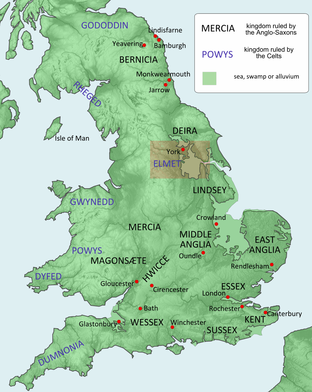
England and Wales in Hild’s time. (Highlighted area in more detail below.) By Hel-hama (Own work) [CC BY-SA 3.0 (http://creativecommons.org/licenses/by-sa/3.0)%5D, via Wikimedia Commons
Britain looked different in Hild’s time. Take a look at the above map and note the pale green areas that were swamp and/or alluvial plains and/or sea. Most have long since been drained and filled and turned into rich agricultural land. But 1400 years ago they could be under water year round, flooded twice a day with the tide, or submerged for months over winter, depending.
Now look at the vast mire between Deira and Lindsey. This, according to Bede, is where the battle of Hatfield Chase1, or Hæðfeld, was fought in 632. It was the final conflict between, on one side, Edwin, king of Northumbria and overking of the Angles, and, on the other, Penda of Mercia and Cadwallon of Gwynedd. Edwin and his son, Osfrith, were killed; another son, Eadfrith, was captured (and killed later). For a while, until Oswald fought and killed Cadwallon at Heavenfield, or Hefenfelth, Northumbria reverted to its constituent kingdoms of Bernicia and Deira
If you add roads and key settlements to a more detailed version of south-west Deira (what is essentially West and South Yorkshire now), you get this:

South-west Deira showing rivers and road circa 632
I haven’t got around to fully annotating this map yet. What you’re seeing is, in blue, the river systems, including the Humber (which becomes the Ouse upstream). The red dots are, from north to south, York, Tadcaster/Cælcacæstir, Caer Loid (the chief vill of Elmet), and Caer Daun (present-day Doncaster). The dark lines are Roman roads (some in much better shape than others, more on which another time). The brown bits are anything over 800′. The tiny green line is Becca Banks, Aberford. This map isn’t massively accurate. The highlighted square, though, reproduced below, has much more detail and those details are as accurate as I could make it.
 Hatfield Chase and Axholme circa 632
632 CE, though, was almost a millennium before Vermuyden’s massive drainage project in the late 16th and early 17th centuries which reset many watercourses. There’s a lot we don’t know (or at least I don’t; I couldn’t find easy-accessible data). I had a go, anyway. I worked out the waterways and contours using a 17th C Dutch map, an article by Joan Thirsk from the ’60s, a 19th C antiquarian’s musings about Elmet, and an article whose antecedents I have disgracefully lost track of—old, judging by the hand-drawn maps—which I downloaded long, long ago on a platform far, far away; its meta-data did not travel with it.2 As you can see, the River Don (highlighted in purple) once flowed into the Trent rather than directly into the Ouse at Goole. This puts a radically different complexion on the landscape.
I haven’t got around to fully annotating this map either. The road Penda and Cadwallon and their army would most likely have used (that part of the alternate Ermine Street generally known as the Roman Rig) ran to the west and is just visible in the bottom left corner, along with Doncaster/Caer Daun. On this detail, I’ve highlighted areas 75′ or more over sea level. I did a lot of work, but extrapolation and research will only take you so far; at some point I just had to guess. That suspiciously straight blue line connecting the Trent and the Idle is a Roman ditch, or canal. That splotch northeast of Caer Daun, with the orange arrow pointing to it, is the only raised area south of the Don accessible from the road without having to wade a formidable water course such as the Torne or Idle. It’s on Hatfield Chase.
Bede tells us Penda, or perhaps Cadwallon, killed Edwin. I assume on the battlefield. I assume, too, that this was an execution, one designed to make a statement and cut the heart from Northumbrian resistance. If that’s the case then the execution had to be visible to both armies. If that was so, then this is where it happened. That little rise is where Edwin lost his head—and perhaps arms and hands. But perhaps there was only time for his head. Penda and Cadwallon were probably in a hurry to storm north and subdue the rest of the country. (That’s what I would have done, anyway.) In which case the next point of Yffing resistance would have been Aberford.
I’d love to get others’ thoughts on this.
1 Where I once got stuck hitchhiking from Hull to London. But that’s another story.
2 I have since tried a reverse image search on TinEye, which obediently crawled 10.854 billion images and came up with nothing.

It makes perfect sense to me. Also, an execution gives you plenty of scope for drama, not to mention modern day resonance.
Oh, drama, yep! Sunset on the Yffings… Chortle.
It could have been an execution but not necessarily. They could have cut his head off after he died in battle. I doubt Edwin or Oswald had any reason to surrender for an execution. Oswald’s head in Durham Cathedral has battle wounds consistent with being killed in battle. On the other hand, they clearly captured his son Eadfrith though he could have been captured after the battle, perhaps how Penda got him and not Cadwallon. I suspect Cadwallon wanted Edwin’s head for show on a pike or spear.
The way I see it, he would have been publicly dismembered, to dishearten the Northumbrians. And the hill (or closest thing to it) was the place to do it. So whether he was dead already or not, his beheading would still have been very visible, I think.
I’m guessing they left his torso up there, and Cadwallon took his head on a pike before him as he tore through Northumbria.
Eadfrith—I think there was something going on there. That Penda took him thinking he might use him later as a puppet king, but once Eanfrith Iding and Osric Yffing claimed Bernicia and Deira respectively, Eadfrith was no use to him, so he killed him. Or it could be that Eadfrith was, on some level, plotting with Penda. I’ve always thought he was a slippery character…
Hi Nicola,
What do you make of the discrepancy between Bede and the Welsh account?
Bede states that a great battle was fought in the plain that is called Heathfield where Edwin was killed on the 12th of October and his head was taken to York.
The Welsh Annals record Edwin’s reign ending in 630…. On the Kalends of January at the battle of Meigen. A Welsh poem, Gofara Braint, claims that Edwin’s head was brought to Aberffraw, the Royal court of the kings of Gwynedd at Ynys Mon (Anglesey). Meigen is documented in the Welsh Triads as being in Cadwallon’s homeland in Wales.
Can this be the same battle?
Good luck with the new blog,
Ed
I think it’s a different battle. I don’t always agree with Andrew Breeze, but in this instance I think you’ll find his piece, “633 and the Battle of Hatfield Chase” (Northern History, March 2014) worth a look.
I’ve chosen to write them as entirely separate campaigns. In the first, pre-Penda, Edwin takes an army (or very large warband, depending on how you want to read it) south and west into Gwynedd where he drives Cadwallon onto Glannauc. But Cadwallon escapes by sea. Edwin then brings the bulk of his men back to Northumbria, leaving Eadfrith nominally in charge of a small occupying force. Their mission is to kill Cadwallon when he reappears.
I then have Cadwallon and Penda team up, take back Gwynedd (and on the way beat Eadfrith hollow at Long Mountain), and for Penda to then return to Mercia while Cadwallon, madly, pursues Eadfrith north where, predictably, Edwin’s superior forces swoop in to save the ætheling. But Cadwallon escapes again. Edwin thinks he’s thoroughly beaten. End of Campaign #1.
Campaign #2 is an entirely more thought-out affair. Cadwallon and Penda take a substantial force north, determined this time. I suspect Penda’s game is more subtle and more long-term than Cadwallon’s. And so the fall-out of the Battle of Hæðfeld is just the beginning of the campaign. But that’s a whole other blog post…
The place highlighted by the arrow would be Lindholm .. Where the old Lindholm hall stands today and is a short distance from Hatfield. There was a stone ford crossing on the river Don at Stainforth 2 and a half miles to the north of Hatfield. There is a ridge of high land from Doncaster to Hatfield which is now the course of the A18 rd … Any army would have used this ridge of dry land in a sea of marsh, moor and fen. I live in the area, so if you think of any information I could help you with ,I will if I can .
Thanks for that. And many thanks for the offer. I’ll probably take you up on it soon! Meanwhile, do you know how old that crossing on the Don is?
Sorry for the late reply … Stainforth (Stoneford in old English) was in the doomsday book which was compiled around 1086.. but the stone ford crossing was ancient ..
John, thanks.
Greetings,
fascinating to see your research and I intend to invest in a copy of Hild !, I live in Doncaster and I have had an interest in the History of the area since I was a Boy, My knowledge of the Battle of Hatfield is base on what I have gleaned locally,
Hatfield was Part of Elmet but was also a sub kingdom in itself called Mecien, which included Misson
and probably stretched up to Rawcliffe, as such it was a buffer state between Deira and Lindsay.
and it was strategically important to Edwin who had Lindsay as a client state, Hatfield gave Edwin access to the North Sea, Lincoln and the wash via the Trent and the Foss Dyke and then down the river Witham to the North Sea. He could sail up the Don to Rotherham and up the Idle to Bawtry He could also access York via the Ouse,
I wonder if the area West of Long Sandal was still hostile to the Saxons being as it was populated by
Celtic Britons (I mentioned long Sandal because there is a recently excavated Roman Fort on the South Bank and a Brigante fort on the north bank of the Don)
also at Long Sandal is the church of St Oswald rumoured to have been built of a site where part of Oswalds body rested after it was rescued/ransomed from the Mercians overnight on its way back to York.
Local history claims Edwin had a Palace at Hatfield, and that the mound of earth in a field opposite the chase Pub know as the ‘Roman grave’ is the last resting place of Edwin’s hearth troop, nearby is Slay Pit lane where a running battle occurred between victors and vanquished.
In relation to your map Doncaster is approx. half a mile from the Don the river and may have bordered the town in earlier times as there was a wharf in Low Fishergate.
The Roman Rig north of the Don was a Brigante Road built to serve the many Forts on the Kingdoms
River Don Frontier with the Roman empire (Gallus frontier) the Britons under Cadwallon probably used the Roman road which came through from Chester Via Buxton to Bawtry gathering recruits on the way from the Peak and Elmet,
Max Adams (the King in the North) thinks the Battle took place near the Roman Road to Castleford
north of Doncaster on the dry Magnesium Limestone Escarpment, He believes Edwin’s remains where displayed at Raven Hill (now called Richmond Hill) Sprotbrough if that was the case the Battle would have been called the Battle of Doncaster.
A better spot would have been nearby Cusworth hill which is adjacent to the Roman Road and about a mile and a half north of the town.
There is also a village called Cuckney near Edwinstowe, which is claiming the battle for itself as a large grave containing 200 slain warriors was found in the Church just after the war, I have written to the ‘Battle of Hatfield investigation society’ and informed them of the battles of the Idle and the Trent
fought in the same period which are better candidates for the occupants of their war grave.
good luck with the next book and I look forwards to your revised map,
Regards Marko
Marko, thank you. I’d love to chat about this more. If you’re willing, please email me via the contact form and I’ll email back.
I read with interest the thought that Cadwllon came via Buxton. There is a tradition in the village of Bradwell in the peak that a battle of some kind was fought at the foot of Smalldale, the lower part known as Gore Lane. The body of a King Edwin was hung from a tree near by, the name still exists as Eden tree house. Is it possible that Edwins body was being talken back to Wales as a trophy? A similar event is said to have happened at Oswestery following a later battle between Northumbria and Mercia.
@Dennis: It’s possible, but unlikely I think. Both Penda and Cadwallon headed north after Hatfield Chase. Cadwallon was there a while, and was killed in Northumberland; I doubt he ever returned to Wales. Penda I suspect was not much interested in Wales, so, no, I’d be surprised if any part of Edwin’s body ended up there.