By now I’m sure you’ve all see the Nature article, “The fine-scale genetic structure of the British population” that’s been getting so much play the last few days.
Essentially, researchers at Oxford University, funded by the Wellcome Trust, analysed genome-wide single nucleotide polymorphism (SNP) data from over 2,000 people living in the UK.1 They made sure that each of their subjects’ four grandparents were born within 80km of each other. To quote the abstract, “This reveals a rich and detailed pattern of genetic differentiation with remarkable concordance between genetic clusters and geography.”
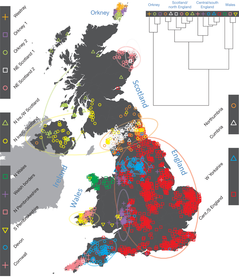
There were several interesting maps and figures included in the article. The first is is the representation of their findings.
Here’s how they map those findings to populations in Europe.

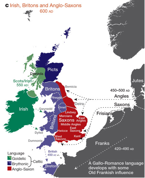
And this is their notion of peoples in Britain at the start of the seventh century.2
To quote the abstract again, “The regional genetic differentiation and differing patterns of shared ancestry…carry clear signals of historical demographic events.” They estimate that the Anglo-Saxons contributed a good chunk, though less than half, of the tested populations’ genetic material in the southeast and that “in non-Saxon parts of the United Kingdom, there exist genetically differentiated subgroups rather than a general ‘Celtic’ population.”
Lots of eyebrow-raising stuff here (for me, anyway). Three things to be going on with:
1. The division between Dyfed and Gwynedd puzzles me. Obviously the mountains were a barrier to intermingling, but the sea has always been a good intercultural route. So why the split? Are tides and currents and winds between north and south so awful? I don’t know enough about that or, clearly, Welsh history. (Any pointers to good information eagerly accepted.)
2. The difference between Dál Riata and Pictland is also distinct but less surprising to me given my understanding of the landscape, both physical and cultural. The division between Dyfneint and Cernyw, though in some ways not surprising (place name and other language markers hint strongly at its existence), in other ways flat out amazes me. Those populations are separated only by a river—which in much of the rest of the isle would be no barrier at all. Just a river…
3. I am oddly pleased by the fact that us Elmetians form our own little subgroup.3
All of this is provocative stuff and will take some mulling, but meanwhile if anyone is willing to venture preliminary thoughts I’d love to hear them. I’m particularly interested in how this might pertain to the endless biological-versus-cultural-replacement discussion.
1 Only the north of Ireland was represented—I don’t know why—so this is the UK, not Britain. It’s a pity; it would have been interesting to see, for example, if the Dublin area mirrored the Danelaw results or if they looked more like Orkney.
2 I snipped this. See the whole thing here.
3 Full disclosure: though my mother and her mother were born in Leeds, my father, and three grandparents (and most great-grandparents) were from all over the isle. I’m a mutt. Eh, hybrid vigour…

Just a river
But rivers can be convenient markers for the establishment of cultural/political boundaries ?
One thing clear from the study is that without some strong external impetus, large parts of the population just didn’t move around very much at all, over a very long period of time.
Perhaps most interesting was the huge disparity between the cultural and genetic influence of the Danish Vikings. Truly unexpected.
Absolutely loved Hild, and am eagerly awaiting the next book.
But if you look at rivers such as the Thames or the Tyne, they functioned more as modes of communication than barriers.
But the Angles and Saxons did, so other factors are at play: laws, language, geography…
I agree: the Viking thing quite surprised me. They must have been men and women in relatively equal numbers, which is a bit startling.
I’m delighted you liked Hild!
Excellent summary, better than the newspaper accounts which were just paltry. There would also have been barriers that are invisible now: really impenetrable forests and their human and animal predators, tribal boundaries, stronger currents for rivers? The Tamar (if that’s the river you mean?) is quite intimidating as a barrier now, if you imagine away the bridges.
Choosing one’s line of descent and affiliating to that, out of all the multi-generational possibilities, is a tricky game. I could go for the line that takes me back to the Macdonald lands on Skye (clansmen, obvs, I’m not a noble), or I could go for the Norfolk or Wiltshire farmers and builders. And what about the great-grandmothers whose lineages were ignored?
Yes, the Tamar. It has (today at least) a decent harbour on the south coast, Plymouth. Perhaps the Tamar isn’t navigable north and west, but if it is—and boats of the time would be be of shallow draft—I don’t see mountains or other obstacles that would prevent people getting off the boat at any point and trading with/travelling to both northeast and southwest. In other words, I can’t figure out why the genes of people from Cornwall and Devon are so different.
The north coast of Cornwall, of course, is home of Tintagel, and there’s archaeological evidence to show that there was a serious power base with trade to and from the Mediterranean, possibly as far as Byzantium, as late as the mid-sixth century. So: two good harbours and the river.
There was a reasonable road, too, heading through Cornwall—certainly to Falmouth—though not Roman. The Roman road system (if you believe the OS Britain the Dark Ages map) petered out about ten miles from Tintagel. (I’m not sure I do believe that; I wonder if it’s more a case if absence of evidence than evidence of absence.)
The more I think about it, the less sense it makes!